Under the Surface
How do you make sense of an inaccessible interior?
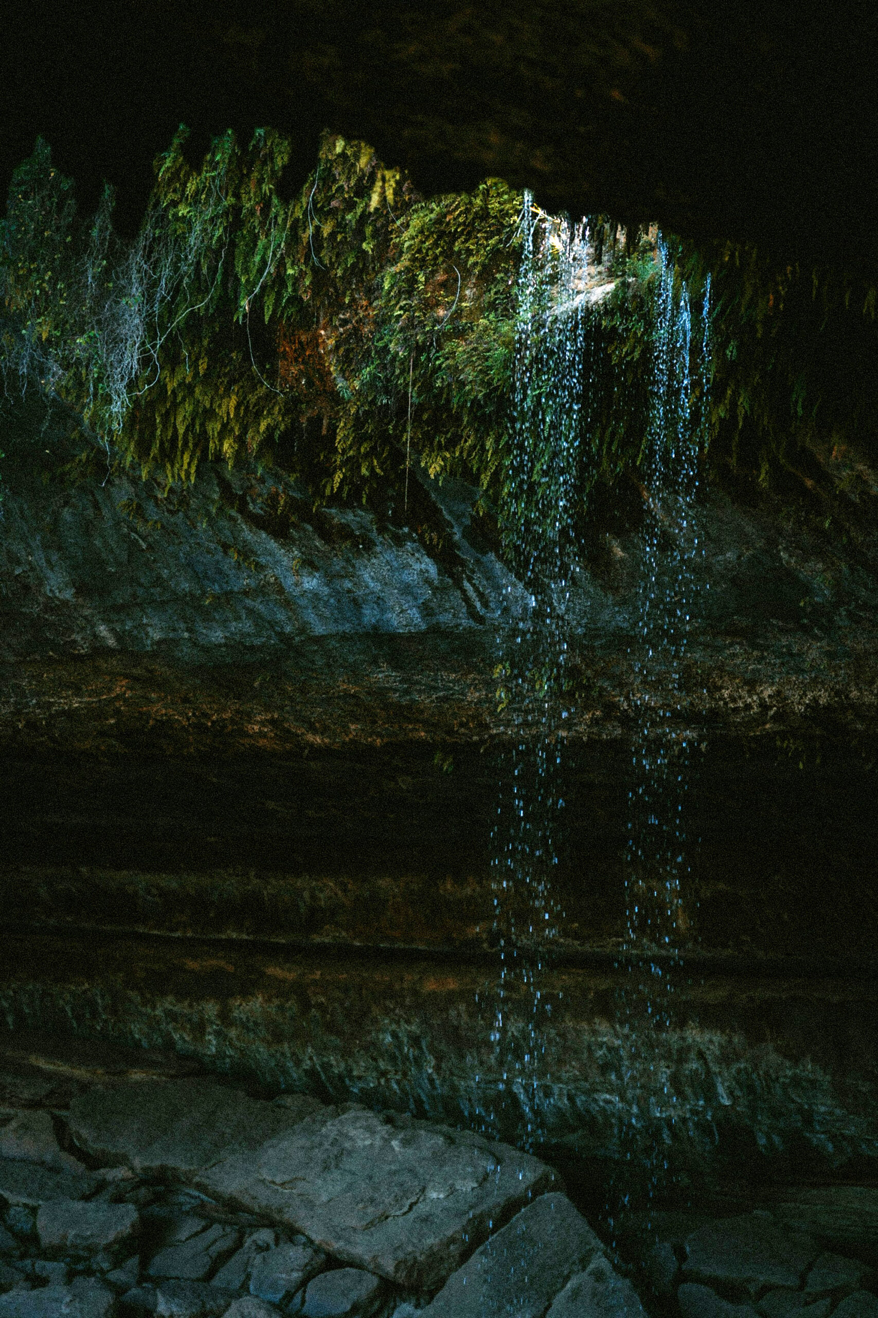
They are neither caves nor mines, but aquifers are also not simply volumes of water. They are saturated substrates—dampened rock, sand, and pores. The United States Geological Survey defines an aquifer as an underground formation saturated to the degree that it can yield water for wells or springs.1 Their inaccessibility to direct observation makes it challenging to sense or make sense of aquifers. Located within the lithosphere, the dermis of the Earth, aquifers exist in an expansive interior that is immense for humans but paper-thin for the planet.
In the twenty-first century, aquifers refuse to remain out of sight. They have become sites of geopolitical struggle, objects of attention for national security projects, and irresistible riddles for planetary science. We know that globally, there is a hundred times more fresh water under the surface than in all rivers, lakes, and swamps combined. Across Central America, projections suggest that by the end of the century, rainfall will significantly decrease, while temperatures will increase by 4ºC/7ºF. Aquifers will become the only stable source of water for human and industrial needs.2
In this context, Costa Rica is going beneath its surface. A country accustomed to looking up to make sense of the rain that falls from the sky, now looks downward to understand the interior of the Earth. This reorientation relies on time, distance, and texture as technoscientific resources. The journeys of scientists, community members, and humanitarians to access the Earth’s interior exemplify the embodied, epistemic, and computational resources needed to make aquifers sensible.
Time
We chat. One of us sits on an empty bucket. The rest stand and watch as water moves downward. Infiltration tests are enchanting procedures. They help determine the likelihood that rain will infiltrate a subsurface and eventually recharge an aquifer. After digging a hole twenty centimeters deep, a premeasured amount of water is poured in from a bucket. One of the team of government researchers starts a chronometer to time how long it takes for the water to infiltrate the soil. Sometimes water presses quickly into the ground, meaning that the soil is sandy. Other times it moves more slowly, indicating that the soil has a high clay component or is already saturated from rain, rivers, or the aquifer itself.
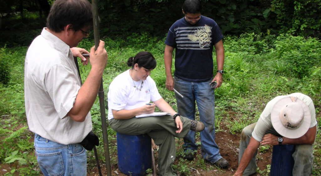
PHOTO BY ANDREA BALLESTERO
Time moves slowly. As we wait, we chat. The topic is political turmoil in the country. After all, we are there because of intense protests opposing the land grabs that resulted from tourism expansion in Costa Rica’s Pacific region, the driest part of the country. In response to the water conflicts that ensued, courts instructed the government to update its scientific knowledge about this aquifer, which supplies water to all residents and businesses in the area. The results of our infiltration tests will feed the models and calculations necessary to understand the aquifer’s condition. These water molecules pushing into the Earth are indices of a new era of climate politics in Costa Rica.
The subsurface is both a distant reference and an immediate concern. Transnational economic forces have turned the region into a desired destination for expats and tourists, which demands more and more water. Scientific evidence of water moving slowly inside the Earth justifies the construction and expansion of new resorts and accommodations.
Our choreographed test—digging a hole, pouring water in, measuring time—mimics the movement of water inward, toward the center of the Earth. After eighteen minutes, there is no more water in the hole. The exact duration is written down. We pick up our tools, get in our cars, and drive from these cattle grasslands to the next site, a riverbank. We expect a sedimentary plain with pebbles, stones, and boulders. Digging our hole will require more effort. Time will be slow. Once again, we will return to our futile conversation about politics.
Distance
Costa Rica, 2024. PHOTO BY ANDREA BALLESTERO
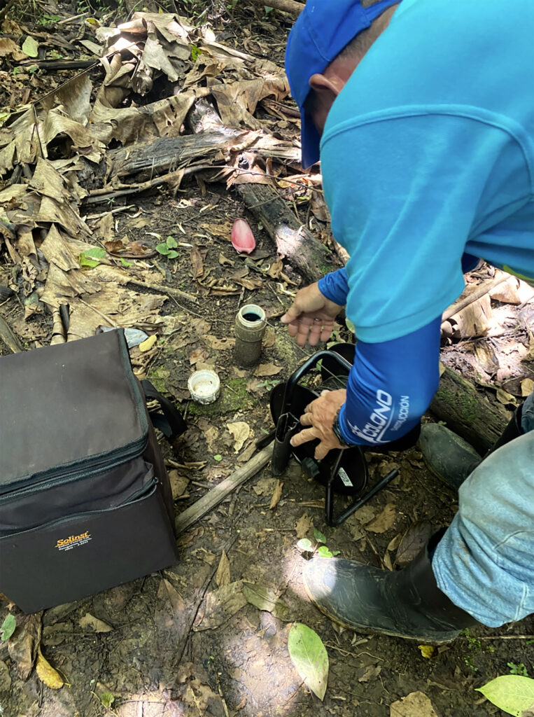
The Green Aquifer Association on Costa Rica’s Caribbean coast collects data from a system of monitoring wells. Once a month, Don Carlos travels by bike on a circuit of about fifteen kilometers, carrying a bag with the necessary instruments to collect data at thirteen wells. He stops at each piezómetro (monitoring well), measures the water level, writes down the data, and later delivers them to a colleague in the office who will transfer the numbers to an Excel sheet and produce a mathematical vision of the aquifer’s health.
On this day, however, Don Carlos is doing the rounds in a pickup truck. The reason is that I and the Association’s newly hired administrative assistant—an undergraduate student doing an internship—want to learn about aquifer monitoring. To reach the piezómetros, Don Carlos drives us through narrow back roads hidden under overgrown grasses. We cross riverbeds that have lost their bridges to flooding. We walk on muddy trails that cattle have turned into slippery pathways.
A piezómetro is used exclusively for monitoring aquifers. It consists of a mechanically drilled borehole lined with a metal casing, inside of which another pipe, usually made of PVC, is fitted. The inner pipe functions as a narrow, vertical tunnel to lower instruments, which detect water levels, measure water conductivity and temperature, and collect water samples for chemical analysis.
Visiting each piezómetro to collect data is repetitive, as scientific monitoring tasks tend to be. This job requires patience, and an openness to routine. Monitoring tasks bring little immediate gratification. Their value rests on sustained repetition. Don Carlos seems well suited for the job. He is observant, analytical, and curious about things that are not fully apparent—the kind of things you learn from long-term monitoring.
The most important tool Don Carlos uses for this task is a water level meter, a battery-operated instrument with a long measuring cable wound around a wheel. An electrode at the tip of the cable emits a high-pitched sound upon contact with water. Once we reach a piezómetro, Don Carlos unlocks the padlock on the well’s lid. He positions the cable, unrolls it, and lowers the electrode down the shaft until it beeps. Beeeeeeep. He makes a few careful adjustments, lowering the cable a few times to find the exact point where water meets air. At that precise location, Don Carlos tightens his grip, and he checks the number on the tape to relay it to the assistant taking notes. The evidence is recorded on a form: our descent into the Earth reached a depth of 5.36 meters—at once an incredible and insignificant distance.
Texture
The promise Don Saud made to his audience at the University of Costa Rica was that the method he was presenting required much less fieldwork than usual, meaning fewer infiltration tests, fewer bike rides to monitor wells. You could get inside the surface of the Earth without needing to puncture its dermis. With this new technology, the sensing work would be performed by algorithms. Texture is the defining criterion. Satellites would record data about the texture of the Earth to infer the aqueous world underneath—decades of scientific, military, and extractive remote sensing technology redirected to aquifer protection in the era of climate change.
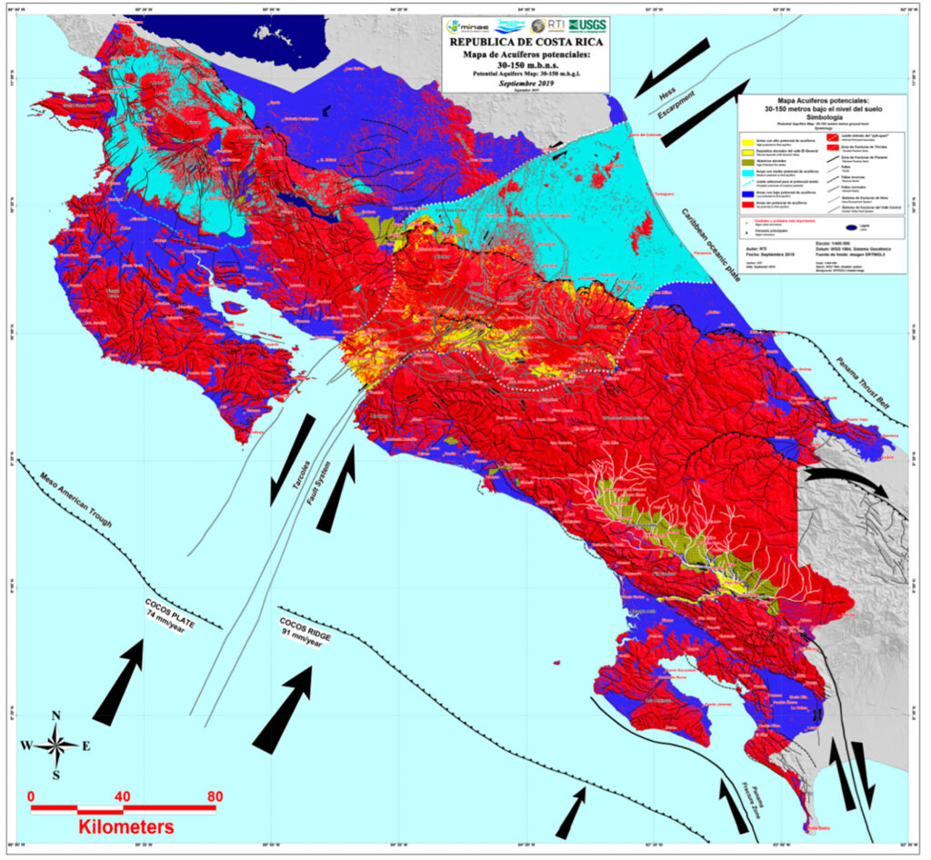
Don Saud represented the US government in an agreement with the Costa Rican Environment Ministry. The collaboration included a contract whereby the Costa Rican state would pay the United States Geological Survey and a private company, Radar Technologies International, $1.5 million to map the country’s aquifers using WATEX™—the method he was presenting. This journey a few hundred meters into the Earth started by first going to outer space and back, riding an algorithm that sorts surface textures.
“Many interiors are inaccessible—
from aquifers to souls. Reaching into them depends on forms of care, scientific practice, and political organization that negotiate this inaccessibility.”
WATEX was an unexpected side product of the frenetic search for minerals, oil, and gas that was characteristic of the late twentieth century. While looking for evidence of mineral deposits in Libya, Alain Gachet, the creator of WATEX, noticed that instead of minerals, his algorithm identified moisture under the surface. The first time this happened, it picked up a broken water line under the Libyan desert. This realization turned into an epiphany for Gachet. Instead of looking for minerals, oil, and gas, he could be a water explorer. Soon thereafter, he left the industry to become a humanitarian advisor. During the Darfur conflict, a test bed for humanitarian intervention, Gachet’s method allowed aid agencies to drill wells that hit water with ninety-five percent accuracy, an extraordinary success rate.
Don Saud was brought to Costa Rica by the country’s ambassador to the United States. While in Washington D.C., the ambassador had heard Don Saud narrate the Darfur story. Many emails, phone calls, and meetings later, Don Saud, Gachet, and WATEX produced an interior out of algorithmic calculations. The project’s outcome was a series of maps visualizing the probability of aquifer presence at various depths (25, 50, and 150 meters).
This pseudo-magical conversion of surface texture into subsurface probabilities into colored maps redirects ambassadors, geologists, and policymakers downward. It allows them to make sense of the world beneath the Earth by using scientific knowledge to organize collective life spatially—to promote investment here or poverty assistance programs there, to offer new tax incentives for tourism here or more agriculture there, to deny a permit for mining here or approve one for new luxury construction there. The interior matters outside. The possibilities of petrocapitalism, military technology, and climate data reveal a future that sits below the surface.
Down to the Future
Aquifers are much more than water. In Costa Rica, they are the knowledge for the state to respond to water conflicts. They are the burden of data collection that rests on the shoulders of local residents on bikes. They are the algorithms that link oil and mineral exploration with humanitarian concerns.
As the pressures of climate change make water conflicts and the outsourcing of scientific practice central features of Costa Rica’s political climate, time, distance, and texture guide our journeys inward. Aquifers disabuse us of the dream of unrestricted access, and they activate the imagination. They demand we learn to relate to that which is out of sight and only partially knowable. Many interiors are inaccessible—from aquifers to souls. Reaching into them depends on forms of care, scientific practice, and political organization that negotiate this inaccessibility. Learning to care for and live with an inaccessible interior is a practical and ethical challenge in the era of climate change. ⦿
- “Principal Aquifers,” United States Geological Survey, accessed March 21, 2025, https://www.usgs.gov/mission-areas/water-resources/principal-aquifers.
↩︎ - Hugo G. Hidalgo et al., “Hydrological Climate Change Projections for Central America,” Journal of Hydrology 495 (2013): 94–112, https:/ doi.org/10.1016/j.jhydrol.2013.05.004.
↩︎